FKT Report: Swan Song Loop in New Hampshire by Ben Nephew
I ponder of something great
My lungs will fill and then deflate
They fill with fire exhale desire
I know it’s dire my time today
– 21 Pilots, Car Radio
This one scared me, literally and figuratively. Where do I start? I guess at the inception, which for me was when Rob Rives first posted it on the FKT site.
I had hiked many of the trails, which includes several of the hardest trails in the Northeast, and the idea of linking them up into a massive loop seemed like the ultimate White Mountain test piece. It is that and then some. I had been wanting to take a hard run, I mean hike, on it for a few years, but was never able to fit it into my schedule and get a reasonable weather day. In addition to the sheer numbers of the route, 31 miles and 16k of climb, I was also drawn by the prospects of King Ravine and the Great Gulf, which I had never experienced. I also thought this Swan Song loop was a much more feasible ultra mountain challenge compared to the Hut Traverse due to the logistical challenges of the Traverse being a 50 mile point to point route. Avoiding the Presidential summits on the Traverse seems odd, and with regards to FKT’s, many of the times on that route do not have GPS tracks, which is confusing.
The weather on the day I decided to drive up and give it a go was very unsettled. I told Steph I would drive up and decide on either the Swan Song or the Grafton Notch Loop when I got up to the Appalachia trailhead. After a late night start to my drive, I pulled into the lot and there were quite a few cars there. Swan Song it is. I got one last higher summits update from a fellow hiker with a smartphone, which was pretty vague and useless, called Steph, and strapped on my battle pack. From knowing the terrain, the unsettled forecast, and stories from Ryan Welts and others, I was worried how this would go. I should have been confident after my earlier races, especially Manitou’s (race report), but while people die in the Catskills and the White Mountains, this result is more common in the alpine regions of NH. Not making it back was not a major concern; I would never put myself in that type of situation, but serious injury on this route is a very real possibility, and I’d be angry with myself if I ended up with an injury or had to bail due to weather or poor pacing.
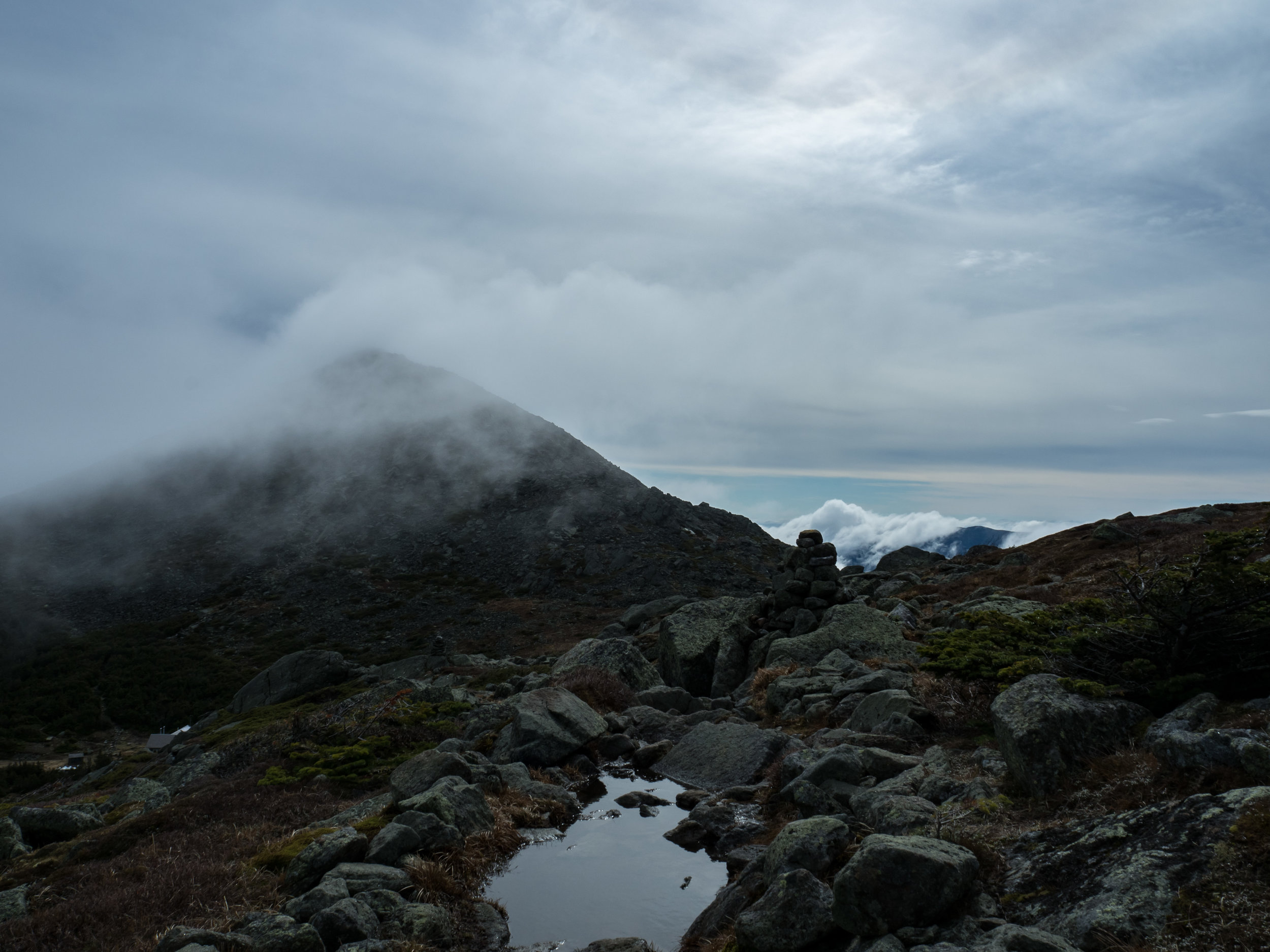
I then started up towards King Ravine at a pace slightly slower than 5-6 hour FKT pace. Air Line and Short Line leading to the King Ravine trail are awesome trails; too nice to just plod along. As I got to the Ravine, I made sure to hit the Subway to be consistent with Adam Wilcox’s current FKT route. This boulder cave scramble is marked, but the markings can be described as aged. This is a common theme on the route as a whole. It was good to get back on the main trail, which is basically a monstrous rock scramble up into the clouds, especially the day I hiked it. This is a full body workout, with all sorts of moves that have absolutely nothing to do with running. Apparently, I was a bit excited on this climb, as I ended up with the Strava CR’s for the Short Line trail and the headwall of the ravine, which is a 1300’ climb over a half mile. Due to the size and shape of the vertically stacked boulders, this section feels even steeper than that at times.
The wind was starting to rip and the sky was dark towards the top of the headwall; this is the first time I thought about bailing. It wasn’t bad enough to put my jacket on, so I kept going. Wind speeds did not improve as I climbed to the jagged summit of Mount Adams, and hanging out up there was not a viable option. I’ve climbed the Star Lake trail, and it is no better going down. My relief at getting off of that lasted about 30 seconds until I started down the Buttress trail. I know it is not possible, but I really think this trail somehow has a net climb. This is the start of the exhausting ultra technical descending that makes this route far different than any other FKT. Buttress is continuous off-camber boulder hopping on a trail that is at most 2 feet wide. You cannot take your eyes off the trail, ever. This made the Great Gulf trail seem like a highway, and I was thrilled to be going uphill rather than downhill.
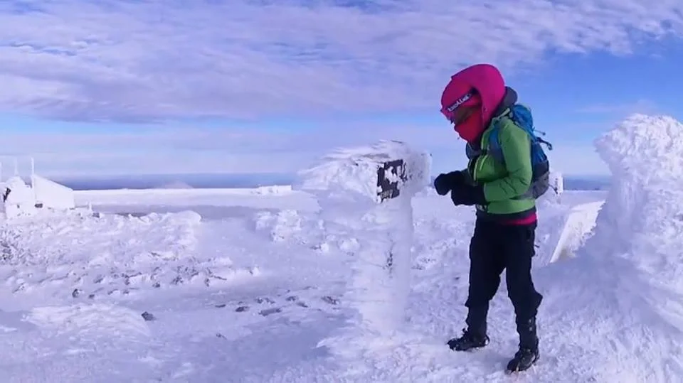
Ascending the Great Gulf involves the only real loose terrain on the route, and when guys like Adam Wilcox can’t stay on the trail, I knew there was going to be some choose your own adventure going on. I managed to stay mostly on the trail and my enthusiasm on this ascent was awarded with another Strava CR. If I had known this at the time, I probably would have backed off. Great Gulf is only 1600’ over 0.7 miles, though. The weather started to get severe as I pulled myself out of the Gulf, and I had to push the pace up to the summit of Washington to maintain an adequate core temp. I knew I was going in the summit building to get water, so there wasn’t any point in putting my jacket on until I got up there. The timing of my run was perfect, I hit the summit at the peak winds of the day, 60-65 mph and rain with temps in the high 40’s or low 50’s. As I came over the summit, two rangers saw me in just my shorts and followed me into the building to make sure I wasn’t going to end up needing some sort of rescue. They watched me put my jacket and hat on; I tried to stop my hands from shaking and making me look like a novice. I was freezing, and the tourists looked at me like I was insane.
Maybe this was a mistake, and I should have run the Grafton Notch Loop. Steph is going to be really mad if I need to be rescued.

I filled my bottles and thought about bailing once more. The weather was supposed to clear in the afternoon, and heading back towards Appalachia right then would have been absolutely miserable. I wasn't sure the FKT was a possibility anymore, but I decided to head towards Tuckerman’s and give it a shot. I was realizing that I would get great satisfaction from just completing the loop, which is not a common sentiment for me. It took a while to get down far enough to get out of the storm, and I was glad to have my Orocs on for the wet, rocky descent to Hermit Lake. As with many trails in the Presidential Range, I have a strong appreciation for the Boott Spur Link, a short, steep climb that seems exponentially longer than its listed mileage. As I crested the Boott Spur Ridge, the skies started to clear, and I had my first somewhat relaxed running down to Pinkham notch. While this trail is relatively tame compared to some of the other paths on this route, it is still steep, rocky, and narrow. It was just such a relief to be out of the cold, driving rain up high.
The more I descended, the more confident I became, and as I got to Pinkham to fill up my bottles once more, I was ready to head up to Huntington’s Ravine. Knowing what I had ahead of me, I had to meter my effort on the run back up Tuckerman Ravine Trail to the turn to Huntington. As the weather cleared, the jacket, shirt, and hat were off and I was back on the FKT mission. My split to Pinkham was encouraging, and I knew I needed to not get overly aggressive on the last two climbs if I wanted to finish with the FKT in one piece. While the Huntington Ravine headwall is easily the hardest hiking trail in the Northeast, the rock scramble approach to the headwall is also long and exhausting, like a series of body shots before the haymakers start raining down. Just as I was getting optimistic as the sun came out and the wind was drying the rocks, the weather took a 180 and it suddenly started raining again. I honestly did not know if it was going to be possible to get up the headwall when it was wet, and the first objective is always to get home safe.
Maybe I should turn back and call it a day. This is crazy.
I would never hike Huntington in the rain, and not just because there are huge signs that tell you not to do this. It is insanely steep rock with few holds and in spots, falls are not a viable option. I looked down at my Orocs, hoped they would not let me down, and decided to go for it. In hindsight, I’m not sure if it was the right decision. I had been running/hiking hard for over six hours, my hands were wet, cold, and tired. By the time I got a quarter way up the face, downclimbing was not a smart option, and resting was just going to result in hypothermia. I had to keep going, and I just wanted to get to the top as soon as I could. This led to me being overly aggressive, and I paid the price with two falls. I was lucky they were short. I was not injured, and I took a moment after self-arresting following the second one.
You can’t fall here, Ben. What are you doing?
The headwall is so steep, my Garmin just froze, didn’t lose signal, just stopped for about 15 minutes. I took more time to find safe routes and checked hand and foot holds the rest of way to rim of the ravine. At times, it was like climbing up a waterfall. I was using individual metal spikes on my Orocs to latch onto millimeter deep ridges on the rock. I’ve never been more stressed in a race or FKT, not even close. Between the fear and the effort, my heart rate was through the roof. The relief of getting back to safe ground above the rim was euphoric; I’ve never been so happy to be on the mass of destruction that is the Northern Presidentials.
That was not smart, at all.
My relief only lasted a short distance onto the rarely hiked Wamsutta trail. I had heard that this trail was special from Ryan, and even though I was expecting chaos, I was shocked at how steep, rough, and tight this trail was. An elevator shaft to hell. It never seemed to end, and after hours of avoiding falls, my left foot slipped off one rock, my leg went down between two rocks, and my shin slammed into the second rock. I saw blood and grabbed my bleeding leg. It made a squish sound, which was not good. It didn’t hurt to put weight on it, and I decided to run for a minute before looking down to see how bad the bleeding was.
I really hope it is not flowing down my leg, I’m not close to help at all.

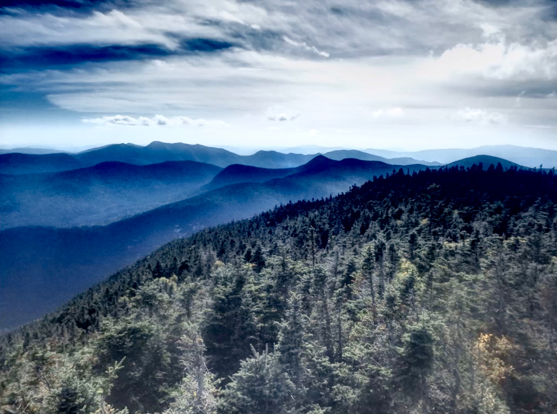
My shin was bleeding down into my sock, but it wasn’t too bad. Luckily I was now onto the Great Gulf trail, and could relax a bit before the turn left up to Madison Gulf. I started up Madison feeling decent considering the ground I had already covered, but the effort from Huntington caught up to me towards the top. It took a massive effort just to keep moving forward, well, more straight up than forward. This was probably at the 0.1 mile on the headwall that climbs over 400’, which is a 78% grade. My legs were ruined, but I just wanted to get to the summit of Madison and be done with climbing. I staggered up Madison, stopped, turned around, and was overwhelmed with the view. The wind was still whipping, but the sky had cleared, and you get an intense and awe-inspiring sense of the massiveness and severity of the Presidential Range from the Madison summit. I ran towards the Watson Path and stopped to take another picture with my mind, as Aiden would say. Whether or not I was going to get the FKT, I was utterly grateful for being able to complete the Swan Song loop.

That was insane.
The problem was, I still had to negotiate the Watson path, which drops 2k’ in 1 mile during the 4k descent. I was wasted, and I’ve never worked so hard to go downhill. The rocks on Madison are jagged and razor sharp, and I kept thinking of Dave Mackey and his accident as I struggled to maintain my balance while jumping over deep gaps between boulders. If you fell on that steep terrain with a leg in one of those gaps, it would just explode. Thanks to Adam Wilcox’s track that ended up being 2 miles shorter than mine, the final miles felt extra-long, just one final psychological torture on a route that can destroy you mentally at every turn. I enjoyed the amazing final mile down the Brookside as much as my battered legs would allow, and stumbled into the Appalachia parking lot feeling as if I had been in the mountains for two days. It is telling that many of us who have spent many a mile in the Whites, Adam, Ryan, Rob Rives himself, are shattered by this challenge. My final time was 11:35:51, good enough for the FKT, but I was just happy to stop moving. The final GPS data was 30 miles and over 19k of climb. After letting Steph know that I was OK, I just sat in my car for a while and ached…

I was far too tired to rinse off in a stream, so I put pants over my bleeding leg, struggled into a long sleeve shirt, and headed over to the Salt Pub to enjoy some awesome food with the locals. It was one of the highlights of the trip. By the time I got home, my pants had attached to the large wound on my leg, and I had to get in the shower with them on and peel them off. My leg ended up taking about 4 weeks to heal; I probably should have gotten a few stitches.

For those wanting to race this loop, it is extremely hard, and the risk of injury is far beyond any other FKT I have done. I used every minute of my 30 years of trail running and hiking experience to survive the Swan Song. However, it is a loop, you pass the Washington summit, Pinkham Notch, and Madison Hut, and there are plenty of bail out options. At the same time, there are plenty of spots where an injury would leave you far from help. For attempting a fast time, this is not for runners who have bad ankles, bad anything, or even a hint of an injury or weakness. Unless you have spiked shoes, I would not run this in wet conditions, or anything other than ideal conditions. This is a challenge that deserves the utmost respect. It exceeded my wildest expectations of challenge, intensity, exhaustion, and ultimate reward and contentment.
After Steph read the race story to Aiden, this is his response…. “I don’t like the bleeding parts. It makes me worried for dada.”