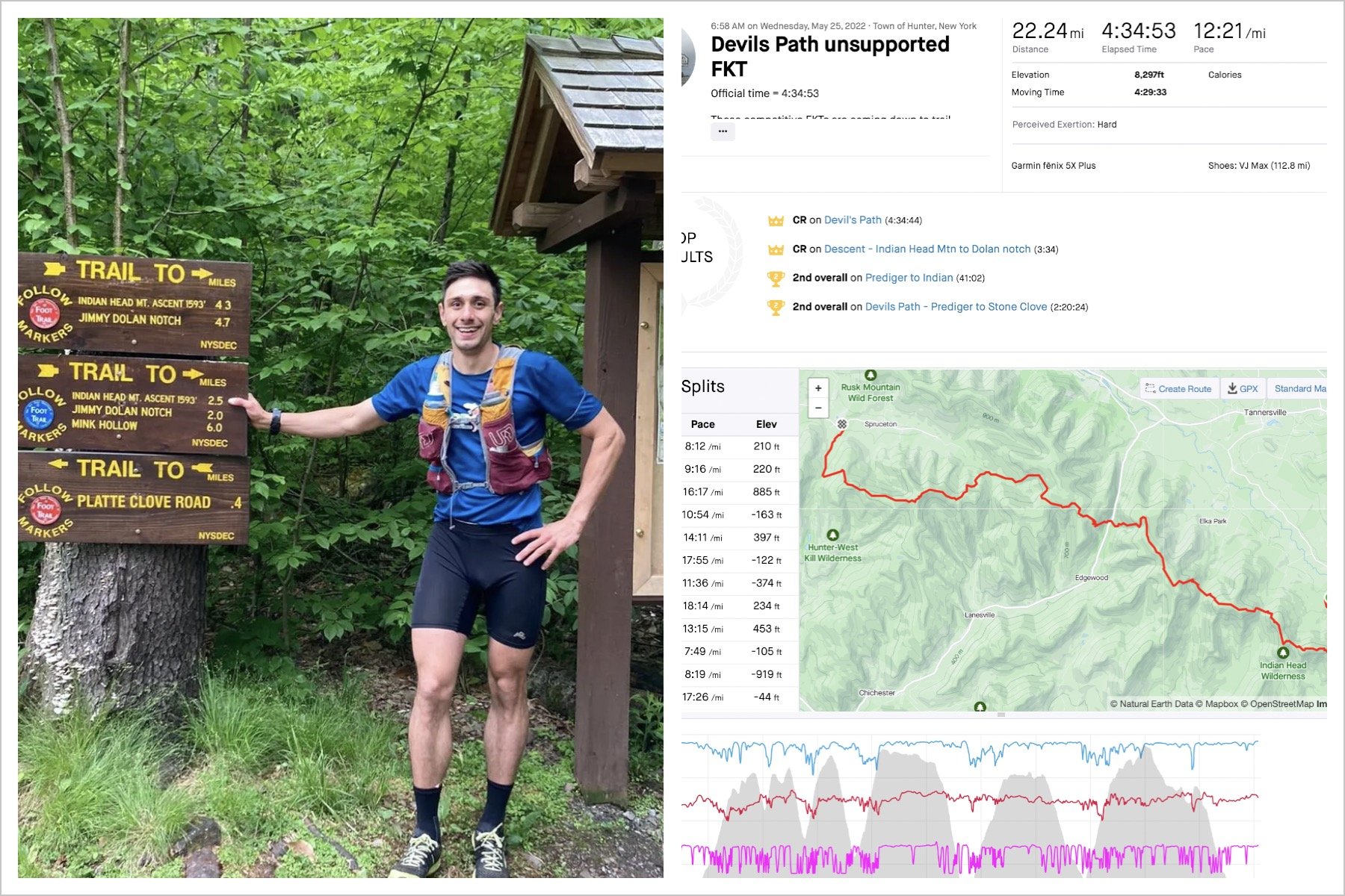
FKT Report: Narragansett Trail in Connecticut by Ben Nephew
Soon after I finished the North South trail in RI, I started thinking about some of the nearby Blue Blazed trails in CT. I had done an out and back on the Nehantic trail and was impressed by how well it was marked and the quality of the terrain. A few people mentioned that the Narragansett Trail was a much more interesting route, and quite a bit more difficult as well. The Narragansett trail (16-18 miles?) starts close to the Nehantic, but then heads southwest, all the way to Foxwoods, over a few ridges and by several ponds, lakes, and streams. While there are long stretches up on ridges, there are also long stretches alongside, or in, streams on the valley floor. There aren’t any major climbs, just numerous small to moderate hills that add up by the end of the run.
It worked out that I had time the day before to go check out the trail and hike a few sections with Aiden, which made for a fun trip. While there are extended sections with no major road crossings, it is easy to parallel the route on the roads and we were able to see most of the road crossing on our way out to Wintechog Hill on the western end of the trail. There are certainly some technical sections on Wintechog, but they are relatively short and the following eastern section is very runnable. I was thinking much of the trail would be like that based on my Nehantic run, but it wasn’t.
The next day, I got a somewhat early start and was on the trail by about 7:30 after the one hour drive from Mansfield. That first northerly section was more like the Great Range than the Nehantic trail, and I was starting to wonder how long my day was going to be. I then hit a runnable stretch around Green Fall Pond, but that was followed by a serpentine trail down through a ravine that involved a good bit of scrambling. It was nice to hit the road for 400m after that. The trail turned onto a low ridge before descending into another ravine. After a short stretch on Tom Wheeler road, the trail crossed through a hunting club, which was difficult to navigate at times. This first 5.5 mile section ended on route 49, which climbed to Ledgendwood Road, a washed out dirt road that led back to the singletrack.
The guide book talks about all these woods roads in this next section, which gave the impression of faster terrain. The problem is that you are mostly just crossing the woods roads, and most of the mileage is spent on technical singletrack. The trail followed a stream bed, quite closely, before climbing up onto several parallel ridges which provided great views of the forest below, especially with all the trees still being bare. I made good time to High Ledge, but my pace started to lag after descending to Wyassup Lake, which I reached in about 1:31. Both sections took me about 45 minutes, and while some have said that the description of the section being 6.5 miles in the guide is wrong and it is closer to 5, it’s certainly faster terrain than the first section.
The next few miles included an extended section along a brook, with several crossings back and forth. The markings were difficult to follow at times, but they improved as the route climbed back up to the ridge overlooking the Yawbucs Valley. The difficult sections reminded me of the middle miles of the Tulley trail, where you feel like you are miles away from anywhere and wonder if you will be able to follow the markings. Once I descended off the ridge, I knew where I was, and was happy to cross route 2 to begin the last few miles to the turn around. There is a runnable section in here, but it is sandwiched by an undulating trail that winds through interesting rock formations and the climb up Wintechog Hill. My hopes at decreasing my average pace over these miles were not realized. I wasn’t surprised to see 2:34 on my watch at the turn, and was pleased with my pace up and down Wintechog, but it was obviously going to be a long day. The plan was to try and run evenly, but as soon as I headed back uphill, this seemed unlikely. Fortunately, the weather was good, and the views from the top distracted me from my premature fatigue.
I started to feel better a mile or two into the second half, and made good time back to Wyassup Lake, running just about the same split as I did on the way out. I still felt decent over the middle section, but I lost some time on the hills, I think. Going through the hunting club was slightly concerning, as there were guys shooting bows at stationary animal targets all over the place. Looking at my GPS data, I ran perfectly even for 4:21 and then slowed 5 minutes in the last 5.5 miles. Over 5 hours, a 5 minute positive split isn’t bad, but it is annoying that it was all in the last few miles. I definitely had to work much harder over the second half, as the constant turns and rolling hills wear on the legs. As for the actual mileage of the trail, based on my GPS which tends to be significantly short, I would guess the trail is about 18 miles.

I want to thank Mike Crutchley for providing updates on course conditions this spring and plenty of details on the route itself. Mike helps to maintain some of the middle miles of the Narragansett, and runs those trails all the time. Aiden and I ran into him just by chance on our hike, which was a pleasant surprise. The Narragansett is a perfect example of how you don’t need big mountains, high altitude, etc. to have a challenging day in the woods. Another benefit of the Blue Blazed trails in CT is that they are in good running condition for much of the year, especially compared to trails up north at higher elevations. One surprise benefit from my run was the discovery of an awesome swimming hole to bring the family to on hot summer days. I will not be disclosing the location!
Visit Ben's page for more reports, articles & results.